Other Notes
Broad Street
Reading's main shopping street, Broad Street was laid out shortly after the foundation of Reading Abbey in 1120. It appeared as 'Brode Stret' on John Speed's map of 1611 and hosted the Glorious Revolution's only battle in 1688. Until 1862, its eastern end comprised two narrow, parallel streets - Butcher Row & Fisher Row.
The eastern end of Broad Street was pedestrianised in 1997 and re-paved with red brick in 2001.
Reading
Reading is a town in the English county of Berkshire. It is regarded as the county town although, since the county council was abolished in 1998, that is a distinction of traditional rather than practical significance. It is the UK's largest town, having been denied official city status no less than four times - in 2000, 2002, 2012 and 2022. As such, it remains a borough, and has held that status since at least the time of the Domesday Book in 1068. A royal charter, granting independence from control by Reading Abbey, was issued in 1253. A second charter was issued in 1542, reflecting the abbey's dissolution in 1538. Since 1998, the borough has been a unitary authority.
How to use Gone Shopping
Use the blue buttons above to navigate up and down the street.

Go to left end of street
This will take you to the scene containing the leftmost building on the side of the street that you are facing.

Go to middle of street
This will take you to a scene that is approximately halfway along the side of the street that you are facing.

Go to right end of street
This will take you to the scene containing the rightmost building on the side of the street that you are facing.

Open street map
This will take you to a page displaying a clickable street map from which you may navigate to any scene in this street.

Go to next left
This will shift you leftwards down the street by one scene.

Go forward
This would let you move forward into an adjoining street. However, there is not yet another street available for you to do that.

Face other side of street
This will turn you about 180° so that you are facing a scene on the opposite side of the street.

Go to next right
This will shift you righttwards down the street by one scene.
The yellow buttons navigate through time.

Open year selector
This will take you to a page displaying all the years that are currently available for the scene that you are looking at, any one of which may be clicked to navigate to that year.

Go to earliest year available
This will take you to the first year available for the scene that you are currently looking at.

Go to previous year
This will take the scene that you are currently looking at back one year in time. (This may or may not look any different depending on whether anything changed between those two years).

Go to next year
This will take the scene that you are currently looking at forward one year in time. (This may or may not look any different depending on whether anything changed between those two years).

Go to latest year available
This will take you to the most recent year available for the scene that you are currently looking at.
Building & Occupier Details

Junction:
Hounslow's Corner
Broad Street ends in the east at a staggered crossroads, where Broad Street, Butter Market, King Street and Minster Street all meet.

East to
King Street
King Street in its modern layout dates from 1760, when two parallel narrow lanes - Sun Lane and Back Lane - were united to form one broader street.

South to
Minster Street
Minster Street has been so named since mediaeval times. It runs from the eastern end of Broad Street to a junction with Chain Street and Gun Street immediately east of St. Mary's Church (aka Reading Minster).
This corner was historically known as Hounslow's Corner, after grocers Hounslow & Co., who occupied no. 134 between 1857 and 1897. Since 2017, Minster Street has been restricted as a bus lane between the hours of 4 pm and 11 am although motorists protest the signage (in King Street) is confusing.

Building:
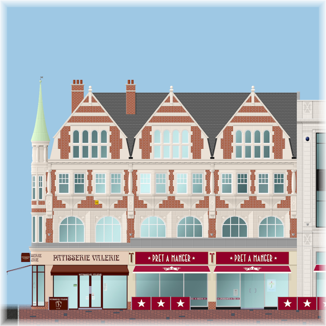
Nos. 132-134, Broad Street
This building, extending into what had then been lately known as Hounslow's Corner, was erected in 1905. It replaced Walsingham House - allegedly built by Elizabethan spymaster Sir Francis Walsingham - and two shops owned by Wellsteed's department store. It was absorbed into the Oracle in 2000.

No. 134
Patisserie Valerie (pâtisserie & café)
Patisserie Valerie is a pâtisserie and café chain founded in London in 1926 by Theo & Esther Vermeirsch. It remained a simgle shop until 1987, after which it expanded rapidly but then collapsed, entering administration in 2019. A management buyout followed but many stores were still closed.


Nos. 132-133
Pret a Manger (sandwich shop)
Pret a Manger (French for 'ready to eat') is a sandwich shop chain founded in London in 1983.
2021 - The second Pret a Manger branch at No. 60 closed, leaving the Oracle branch the only Pret a Manger in Broad Street.
 Home
Broad St
Q&A
Icons
Progress
Home
Broad St
Q&A
Icons
Progress